Abruzzo: Alba Fucens
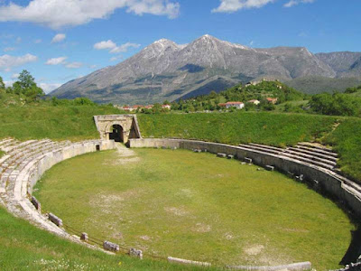
Alba Fucens was an ancient Italic town occupying a lofty location (1,000 m) at the foot of the Monte Velino, c. 6.5 km north of Avezzano, Abruzzo, central Italy. Its remains are today in the comune of Massa d'Albe (few miles from were i live).
It was originally a town of the Aequi, though on the frontier of the Marsi, but was occupied by a Roman colony (304 BC) owing to its strategic importance.
It lay on a hill just to the north of the Via Valeria, which was probably prolonged beyond Tibur at this very period. In the Second Punic War Alba at first remained faithful, but afterwards refused to send contingents and was punished.
It can reach Alba Fucens along highway A24-A25 towards Pescara , if you go to Rome or L'Aquila, if you come from Pescara instead just take the A25 towards Rome.
The outputs at toll of both paths will take place at Avezzano or Magliano dei Marsi . Once you leave the highway, it will be easy to frame the isolated hill of Alba in the northwest corner of the plain of Fucino. During the Social Wars Alba is always loyal to Rome, holding out against the rebellious members assaults. At the end of the war, with the application of the Lex Iulia Municipalis de Civitate danda, the city, as all Italy, obtained the municipal regulations and the roman citizenship.
During the imperial time alba lives a great economical prosperity period. In these years public and private monuments are embellished and modernized, while new buildings are built. All this welfare was due to the economic growing that led to the lake Fucino draining. The colony crisis and decline start in the IIIrd century A.D. and get worse in the IVth century owing to some seismical events and to frequent barbarian invasions, causing the progressive desertion of the city. In the IXth cen., because of the feudal battlements case, the built-up area is on the acropolis where a medieval village is setting up round the castle.
Since 1949 The Alba Fucens site has been excavated by Joseph Mertens a Professor at Belgium's University of Louvain. He has created an artist rendering of the city complete with its 4 portals, forum, thermal baths, amphitheatre, houses & sewage system whose remains with the map it is possible to make out without too much double guessing. Sadly the tourist office there only displays this, seemingly not giving handouts, so either take a picture of their poster display on your digital camera or phone to refer to or print it out ready. Whilst here do visit the site's nearby Apollo Temple that Benedictine Monks re-minted into Church of San Pietro.
It was originally a town of the Aequi, though on the frontier of the Marsi, but was occupied by a Roman colony (304 BC) owing to its strategic importance.
 |
| Alba Fucens |
The outputs at toll of both paths will take place at Avezzano or Magliano dei Marsi . Once you leave the highway, it will be easy to frame the isolated hill of Alba in the northwest corner of the plain of Fucino. During the Social Wars Alba is always loyal to Rome, holding out against the rebellious members assaults. At the end of the war, with the application of the Lex Iulia Municipalis de Civitate danda, the city, as all Italy, obtained the municipal regulations and the roman citizenship.
During the imperial time alba lives a great economical prosperity period. In these years public and private monuments are embellished and modernized, while new buildings are built. All this welfare was due to the economic growing that led to the lake Fucino draining. The colony crisis and decline start in the IIIrd century A.D. and get worse in the IVth century owing to some seismical events and to frequent barbarian invasions, causing the progressive desertion of the city. In the IXth cen., because of the feudal battlements case, the built-up area is on the acropolis where a medieval village is setting up round the castle.
 |
| Monte Velino |
Since 1949 The Alba Fucens site has been excavated by Joseph Mertens a Professor at Belgium's University of Louvain. He has created an artist rendering of the city complete with its 4 portals, forum, thermal baths, amphitheatre, houses & sewage system whose remains with the map it is possible to make out without too much double guessing. Sadly the tourist office there only displays this, seemingly not giving handouts, so either take a picture of their poster display on your digital camera or phone to refer to or print it out ready. Whilst here do visit the site's nearby Apollo Temple that Benedictine Monks re-minted into Church of San Pietro.


Comments
Post a Comment
Thanks for leaving your comment